
With its unique position between the Sierra Almijara mountains and the Mediterranean, Nerja makes an ideal place to stay for those who like to mix more active pursuits in with their sunbathing!
Nerja lies at the foot of the Sierra Almijara, and the most eastern part of this mountain range is known locally as the Sierra of Nerja. The landscape is quite unique for the Malaga coast in that here there are high mountains very close to the sea; in fact it seems that they plunge straight into the Mediterranean! This has the effect of creating sheltered sandy coves and a spectacular rugged coastline.
 Nerja is an ideal choice for your base, as you are right by the mountains but at the same time you are not staying ‘in the middle of nowhere’. You have all the amenities of a thriving town, such as supermarkets & chemists and a wide range of restaurants and bars to visit.
In the evening Nerja is ideal for sampling the local cuisine and you can join the locals and tourists who gather on the “Balcon de Europa” which juts out into The Mediterranean Sea and has a colourful atmosphere with street entertainers and stalls from local artists.
The best time to walk in Andalucia is in the late spring early summer when the flowers are in bloom, and in early autumn to catch the migration of birds. The region lies on the most important migration route for birds from northern Europe to Africa and many exotic species pass through, or are permanently resident (such as griffon vultures and flamingos). However the generally sunny climate of Nerja makes walking attractive even in the winter months, and in the hot summer we offer river walks – to take advantage of the cooler temperatures by the water and, of course, giving you the opportunity to cool off in the water en route.
Self-guided walks
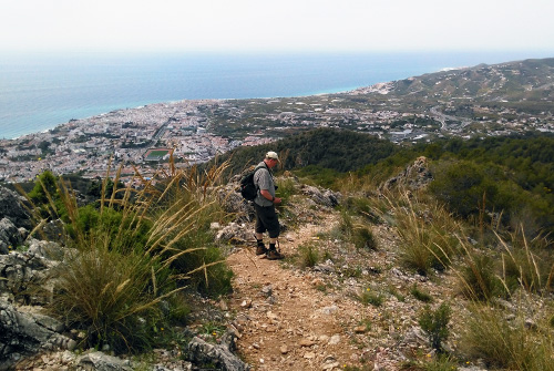
As walking enthusiasts ourselves, we have put a lot of work into planning, exploring and writing up a significant number of walks that can be undertaken from Nerja itself, together with other local start points, such as Torrox, Frigiliana and Maro. These walks can very readily be done without the need for a local guide. Numerous other sources do provide similar information, but it is our experience that most of the published routes that you may come across elsewhere, contain ambiguities that can lead to uncertainty as to which way to go (the area is full of old mule tracks and the like, and roads get up and down graded, as well as sometimes being blocked off). And going wrong in an area of this complexity can be a real downer!
We would like to emphasise, therefore, that all of the self-guided routes that we ourselves recommend have been exhaustively researched by us. Full walking directions are given on the individual webpage that accompanies each walk. However, and as an additional service, we have added a series of downloadable PDFs to accompany each walk that we describe, in which we have taken great care to ensure that all route descriptions are as full and accurate as possible, with GPS-generated maps, and photographs of ambiguous junctions etc. They also contain details of things to see along the way, historical notes and so on. Although we say it ourselves, we do believe, therefore, that our walking descriptions are by far the best on offer in this area.
Full details of all of these walks can be found on our accompanying website, NerjaWalking.com, but the following summaries will give you a brief insight into the sort of thing that we have to offer.
Please note however that these walks are not continually checked and we cannot guarantee that they remain as stated in our descriptions.
Ermita de San Isidro (10km)
The Ermita is a small chapel, or shrine, located on top of a decent-sized ridge, giving some excellent views of Nerja and the surrounding countryside. San Isidro is the patron saint of farm workers, and celebrations in his honour take place throughout Spain on the 15th of May each year. This route takes you across the River Chillar and along paths and tracks until you reach the ridge where the chapel is situated. The return route brings you back a different way, crossing another riverbed (the Rio Seco, or Dry River) and then through avocado and lemon plantations until you reach the main road through Nerja again.
Click here to read a more detailed description of the route.
The Old Drover Route (11km)
This walk is one that we have devised ourselves, basing it around a number of old drover routes in the vicinity of Nerja. Needless to say a good proportion of the route is now comprised of concrete roads, created for the benefit of various fairly recently constructed villas, but the spectacular views remain, as also does, hopefully, its historical context. It takes you along the ‘Camino Viejo de Málaga’ (The Old Malaga Pathway) up to the hamlet of La Molineta, which is just below Frigiliana. From here, you join another old route ‘El Camino de la Molineta’ which takes you back down crossing two river beds, the Río Higuerón and then down to the Río Chillar.
Click here to read a more detailed description of the route.
Torre de Maro (12 km)
The ‘Torre de Maro’ is one of a series of 16th Century watch towers set in prominent locations on cliff tops along the coast in order to provide warnings, historically, of raids from North Africa. This route takes you from Capistrano Village to the tower and back via a different route, although if you wished to make the route shorter you could start from the village of Maro itself. (continued on next page)
The route from Capistrano takes you via the ruins of the old San Joaquin Sugar Mill, and a short detour provides views of the Puente de Aquila aqueduct. After reaching Maro you then follow tracks and a rough path up to the tower itself.
The views from the tower are well worth the climb. Looking out to the right you can see the Playa de Maro in the mid distance, and Nerja’s Balcon de Europa in the far distance. Looking the other way, you will see an equally dramatic view of the coast towards La Herradura. Then looking inland you can see part of the striking mountain range that graces this stretch of the coast.
Click here to read a more detailed description of the route.
Fuente del Esparto (14 km)
This is a walk from the entrance to the Nerja Caves to the El Pinarillo picnic area north of here, together with an extension to the Fuente del Esparto, or Fountain of the Esparto Grass (which is a coarse grass with tough narrow leaves, native to Spain and North Africa, and which is used to make ropes, wickerwork, and high-quality paper). It is a ‘there and back’ walk but this is no downside in an area as beautiful as this, with spectacular views, and the experience coming down from the top is quite different to that going up. However there are alternative return routes possible for the more adventurous.
Don’t be disappointed if you were expecting the fountain itself, at about 6 ½ km, to be a huge and majestic structure, dating back to antiquity. The spring that feeds it was re-constructed as recently as 1994, as the plaque on the back wall of the fountain relates, and is certainly regarded a quite drinkable. Slightly beyond the fountain are some newly constructed buildings, including a small café, although its opening times are not documented. It is worth continuing on up the hill for another km or so until you reach the summit of the ridge, with some splendid views to the valley below. In order to reach the absolute peak you need to take a track to the left which is comprised of some quite loose stones, which are easy enough to climb up on, but somewhat slippery on the descent, so that walking poles will be a help here. The views from the summit are quite spectacular.
Click here to read a more detailed description of the route.
Cruz de Pinto (12 km)
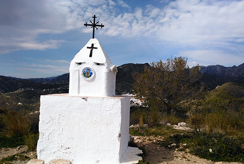 During this walk we reach the peak of Cerro del Pinto, a rounded hill to the north of Nerja, between the Higuerón and Chillar river valleys, and named after a 16th Century sea captain. Legend has it that Francisco de Pinto and his crew were caught in a terrible storm. In fear of their lives, the captain swore that if they were spared he would erect a cross in gratitude on the first land they sighted.
As they approached the coast, this was the first hill revealed through the storm clouds and Pinto duly raised a simple wooden cross upon it to honour his promise. Later replaced by today’s more elaborate shrine, it became a popular place of pilgrimage.
Once you reach the shrine it is well worth taking the time to enjoy the views. Looking straight ahead, for example, it is quite a surprise to find that not only are you almost level with the mountain village of Frigiliana, but considerably higher than it too. The return route takes you down to the river bed of the Rio Higueron and then along its course (you may get your feet wet at some point!) until it joins the Rio Chilar, and then follows the same path as your outbound route to return you to Capistrano Village.
Click here to read a more detailed description of the route.
Additional Information
In addition, the Nerja Tourist Office produces a leaflet “The Sierra of Nerja and the Cliffs of Maro” and you can pick up a copy from the Tourist Information office in the town hall, near the Balcón de Europa. The sketched maps may not always be easy to follow and there are a few translation issues, but it does give you a wide range of routes to choose from in the area.
El Pinarillo
El Pinarillo is a picnic and barbeque area in the heart of the Sierras de Tejeda, Almijara and Alhama Natural Park and a popular base for ramblers and walkers.It is situated about 5kms inland from the Nerja Caves and to get there, just follow the track which starts to the left of the main entrance to the Nerja Caves.
Normally, although the route up to El Pinarillo is an unmade road and a little rough in places, a 4×4 is not essential. However heavy rains this winter have made the road very uneven and not suitable for passing unless in a 4×4. The situation may change if the road is repaired. Access by bicycle or on foot is still possible. Once at the picnic area, there is ample parking. There are purpose-built barbeque areas and play areas for the kids.
From El Pinarillo, the world is your oyster as far as walking and exploring the countryside is concerned. Long walks, short walks, whatever you want, and the views are fabulous. Or just spend a leisurely day having a picnic or barbecue and enjoying the fresh air! There is plenty of flora and fauna – masses of butterflies, especially in the Spring, wild mountain goats, lizards, snakes, wild orchids and a host of other colourful wildflowers.
Please note, however, that vehicular access to the National Park, including up to El Pinarillo, is restricted between June and October and barbecues are not permitted during this period. This is due to strict fire regulations now in place to prevent forest fires during at a time when the countryside tends to be tinder dry. You can still enter on foot, bicycle or horseback. El Pinarillo is the starting point for several of the Tourist Office walking routes.